


Descripción de Surveying Calculator
Surveying Calculator has commonly used land surveying tools. This includes coordinate geometry calculations, offline point data collection, displaying CAD, GIS, raster data and online maps in QGIS 3 project format. Surveying Calculator supports QGIS 3 projects. (qgs, qgz)
Features:
- Jobs:
→ Create unlimited jobs for collecting points in SHP or GeoPackage formats with coordinate system code (EPSG code).
→ You can also prepare a job in QGIS on desktop with geospatial data. Import CAD, GIS, raster data or add online map services in QGIS. And transfer the data folder to Surveying_Calculator/projects folder on your device. Select the project in Jobs and Start Survey.
- Start Survey:
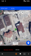
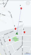
→ Collect unlimited points with "name" and "description". You can record your location or any place you want.
→ Add point with coordinates ( x, y or latitude, longitude).
→ Make surveying easy using QGIS projects.
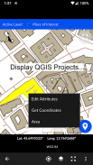
- Map Viewer: Displays QGIS 3 projects.
→ It is possible to include geospatial data to display maps on this app;
→ Raster (GeoTIFF, DEM, JPEG, PNG, GRD, XYZ, ..),
→ CAD (DXF, DGN v7),
→ GIS (ArcGIS shp, Google Earth (kml, kmz), GeoJSON, GPX..),
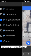
→ Online map services (Open Street Maps, Hybrid Maps, Satellite Maps, Terrain Maps..) Online maps can be prepared using QuickMapServices plugin in QGIS. You can add Open Street Maps, hybrid or satellite maps in QGIS project for Surveying Calculator.
→ Geodatabase (GeoPackage, Spatialite) formats in QGIS projects.
- Coordinate System support:
→ Supports 5000 different EPSG coordinate systems.
→ User can search a coordinate system with country name or coordinate system name on epsg.io site. And user can create jobs with a proper EPSG code.
→ The coordinate system can be projected ( in feet or meters units) or geographic (in degree)
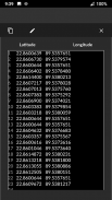
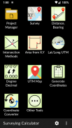
- Generate Coordinates: Generate coordinates in latitude/ longitude or in X, Y.
- Basic Surveying Tools: X(N), Y(E) Calculation, Distance, Azimuth Calculation, Interior Angle, Latitude Longitude from point, distance and bearing
- Intersection Methods: Forward Intersection, Line - Line Intersection, Circle by 3 Points
- Distance between Coordinates: 2D, 3D distance from X, Y and distance from Latitude, Longitude
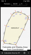
- Area calculation from coordinates
- Degree - Decimal Conversion
- Coordinate Converter: WGS84 Latitude/Longitude to UTM XY or UTM XY to Latitude/Longitude Conventer, 2D Helmert transformation
- Settings: Coordinate order of northing, easting or latitude, longitude. DMS or decimal options for geographic coordinate systems. Scale bar unit settings in metric or imperial.
- and more.
Surveying Calculator supports Android 6.0 and up. Minimum 2GB RAM with 300MB free space are recommended.
Some of the new modules have bugs with the new update:
- Start Survey: The app sometimes closes unexpectedly when GPS button is active. To prevent this problem, turn off GPS mode before exiting Start Survey.
- Scale bar sometimes gives wrong results after adding layers and storing points.
- Projects sometimes display rotated map on Start Survey and Map View.
- Points are sometimes not recorded in Geopackage format.
It is planned to fix the weird bugs for next updates.
If you need help or if you have any suggestion about this app please mail to geosoft@gmail.com or join Surveying Calculator Facebook group to ask questions. You can follow news about the app on Facebook Page:
fb.me/surveyingcalculator
La Calculadora de topografía ha utilizado comúnmente herramientas de topografía. Esto incluye cálculos de geometría coordinada, recolección de datos de puntos fuera de línea, visualización de CAD, GIS, datos ráster y mapas en línea en formato de proyecto QGIS 3. Surveying Calculator es compatible con proyectos QGIS 3. (qgs, qgz)
Características :
- Trabajos :
& rarr; Cree trabajos ilimitados para recoger puntos en formatos SHP o GeoPackage con el código del sistema de coordenadas (código EPSG).
& rarr; También puede preparar un trabajo en QGIS en el escritorio con datos geoespaciales. Importe CAD, GIS, datos ráster o agregue servicios de mapas en línea en QGIS. Y transfiera la carpeta de datos a la carpeta Surveying_Calculator / projects en su dispositivo. Seleccione el proyecto en Empleos e Iniciar encuesta.
- Iniciar encuesta:
& rarr; Acumula puntos ilimitados con "nombre" y "descripción". Puede grabar su ubicación o cualquier lugar que desee.
& rarr; Agregue un punto con coordenadas (x, y o latitud, longitud).
& rarr; Facilite la topografía utilizando proyectos QGIS.
- Visor de mapas: muestra proyectos de QGIS 3.
& rarr; Es posible incluir datos geoespaciales para mostrar mapas en esta aplicación;
& rarr; Ráster (GeoTIFF, DEM, JPEG, PNG, GRD, XYZ, ..),
& rarr; CAD (DXF, DGN v7),
& rarr; SIG (ArcGIS shp, Google Earth (kml, kmz), GeoJSON, GPX ..),
& rarr; Servicios de mapas en línea (Open Street Maps, Hybrid Maps, Satellite Maps, Terrain Maps ...) Los mapas en línea se pueden preparar utilizando el complemento QuickMapServices en QGIS. Puede agregar Open Street Maps, mapas híbridos o satelitales en el proyecto QGIS para Surveying Calculator.
& rarr; Formatos de geodatabase (GeoPackage, Spatialite) en proyectos QGIS.
- Soporte del sistema de coordenadas:
& rarr; Admite 5000 sistemas de coordenadas EPSG diferentes.
& rarr; El usuario puede buscar un sistema de coordenadas con el nombre del país o el nombre del sistema de coordenadas en el sitio epsg.io. Y el usuario puede crear trabajos con un código EPSG adecuado.
& rarr; El sistema de coordenadas se puede proyectar (en unidades de pies o metros) o geográfico (en grados)
- Generar coordenadas: Generar coordenadas en latitud / longitud o en X, Y.
- Herramientas básicas de topografía: Cálculo de X (N), Y (E), distancia, cálculo de acimut, ángulo interior, latitud, longitud desde el punto, distancia y rumbo
- Métodos de intersección: Intersección hacia adelante, línea - intersección de línea, círculo por 3 puntos
- Distancia entre coordenadas: 2D, distancia 3D desde X, Y y distancia desde latitud, longitud
- Cálculo del área a partir de coordenadas
- Grado - Conversión decimal
- Convertidor de coordenadas: WGS84 Latitud / Longitud a UTM XY o UTM XY a Latitud / Longitud Conventer, transformación 2D Helmert
- Settings: Coordina el orden de norte, este o latitud, longitud. DMS u opciones decimales para sistemas de coordenadas geográficas. Ajustes de la unidad de barra de escala en métrica o imperial.
- y más.
Surveying Calculator es compatible con Android 6.0 y versiones posteriores. Se recomienda un mínimo de 2 GB de RAM con 300 MB de espacio libre.
Algunos de los nuevos módulos tienen errores con la nueva actualización:
- Iniciar encuesta: la aplicación a veces se cierra inesperadamente cuando el botón GPS está activo. Para evitar este problema, apague el modo GPS antes de salir de Iniciar encuesta.
- La barra de escala a veces da resultados incorrectos después de agregar capas y almacenar puntos.
- Los proyectos a veces muestran mapas rotados en Iniciar encuesta y Vista de mapa.
- Los puntos a veces no se registran en formato Geopackage.
Está previsto corregir los errores extraños para las próximas actualizaciones.
Si necesita ayuda o si tiene alguna sugerencia sobre esta aplicación, envíe un correo electrónico a geosoft@gmail.com o únase al grupo de Facebook de Surveying Calculator para hacer preguntas. Puedes seguir las noticias sobre la aplicación en la página de Facebook:
fb.me/surveyingcalculator
Surveying Calculator - Versión 3.5.4
(08-02-2021)Surveying Calculator - Información de APK
Version de la app: 3.5.4Paquete: org.project.geoclassApps en la misma categoría
Quizá también te interese...


